
Karan: “Hey, good morning! How was your flight? When do you start the new job?”
Arjun: “It was fine. I’m starting next week, and I’m supposed to head to Sindhudurg. Thanks again for referring me to the analyst position. Since you said you’d guide me, I went ahead and took the job. The thing is, I don’t even know where Sindhudurg is in Maharashtra. I’m a bit worried because my job involves traveling, and I don’t know much about the region or politics.”
Karan: “Don’t worry! I told you I’d guide you, and I will.”
Arjun: “After Sindhudurg, they mentioned I’ll have to travel to Aurangabad and then to Amravati. Are those places close to each other? I’ve been Googling, but I’m getting more confused.”
Karan: “No need to get confused. Instead of random searches, I’ll give you a clear and simple overview of Maharashtra’s geography.”
Arjun: “That would be great! Please do.”
Karan: “Alright, let’s start with the basic geographical divisions.”
Geographical Understanding
Karan : “Let me make it easier for you—I’ll show you on a map.”
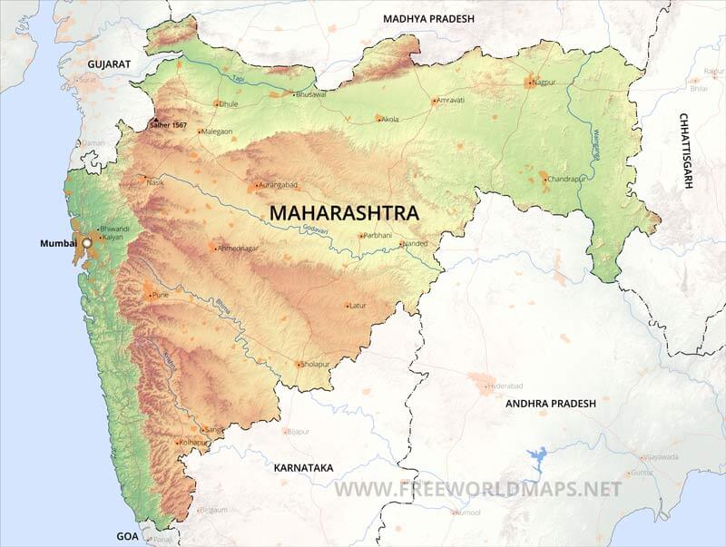
Karan: “Maharashtra is centrally located along India’s western coastline, with Mumbai as its capital. It shares borders with several important regions:
- To the north: Gujarat and Madhya Pradesh
- To the east: Chhattisgarh
- To the south: Karnataka and Telangana
- To the west: Arabian Sea
- To the northwest: Dadra and Nagar Haveli
As for its position, it lies between 16°N and 22°N latitude and 72°E to 80°E longitude. Maharashtra’s strategic coastal location gives it easy access to inland and maritime trade routes, with Mumbai being a key economic centre.”
Arjun: “I had no idea about these facts concerning my own state!”
Karan: “That was just to give you some context. Let me now break down the main geographical divisions of Maharashtra for you.”
Major Divisions of Maharashtra
1. Konkan Plains
2. Sahyadri
3. Plateau Region
Konkan Plains
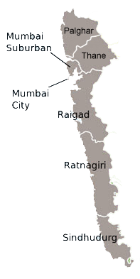
Karan: “The first place you’re headed to, Sindhudurg, is located in this region.”
Arjun: “Now it’s starting to make sense!”
Karan: “The Konkan coast runs from Bordi Talasari Creek in the Palghar district in the north, down to the Terekhol river creek in Sindhudurg district in the south. It’s a narrow, tapered region extending southwest, with a steep slope from east to west.”
- The length of the Konkan coastline is 720 km.
- The Konkan coastline is not a straight line but curved in places. That is why the Konkan coast is also called Dantur.
- The width of the Konkan coastline ranges from 30 to 60 km and the maximum in the Ulhas river basin is up to 100 km.
- The area is 30,394 square kilometres.
- On the Konkan coast, Ratnagiri has the highest beach and Thane has the lowest
Konkan Coast : North Konkan ,South Konkan, Khalati , Valati
Ports : Approximately 49 ports , Mumbai major port , small ports like Alibaug, Murud, Shirivardhan, Raigad, Ratnagiri
The region also boasts beautiful beaches and key ports, with Mumbai Port being a major hub of business activity. (Yes, it’s where a lot of trade happens).
Arjun: “Beaches? Great! I can relax by the beach after work. I’m excited!”
Karan: “I know ‘beach’ makes you think of bikinis and beachwear, but don’t get too excited—you won’t find that here! Plus, work won’t leave you with much free time anyway.”
Plateau Region
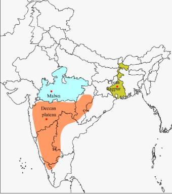
The Maharashtra Plateau is part of the larger Deccan Plateau, which covers a significant portion of the state. Sub regions include Vidarbha plateau, Western Maharastra Plateau, Marathwada Plateau.
Cities like Aurangabad are known for their historical monuments like the Ajanta and Ellora Caves, which are UNESCO World Heritage Sites.
Arjun: “Alright, so Aurangabad is in this region. Got it!”
Karan: “Now, let’s move on to the Sahyadris.”
Sahyadri
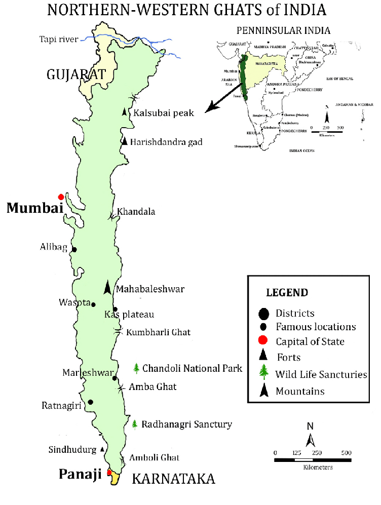
In Maharashtra, it has an average elevation of 900 to 1,200 meters. Famous peaks include Kalsubai (the highest peak in Maharashtra at 1,646 meters), Harishchandragad, Mahabaleshwar, and Rajmachi.
Districts: Mumbai Suburbs , Raigadh , Thane, Pune, Satara , Kolhapur , Ratnagiri, Sindhudurg , Nashik
Hill stations : Lonavala, Khandala, Matheran, Mahabaleshwar, and Panchgani,
National Parks and Wild life sanctuaries: Sanjay Gandhi National Park, Bhima Shankar Wildlife Sanctuary, and Koyna Wildlife Sanctuary.
Karan: “So, do you have a broader understanding now? If you get the chance during your travels, try to visit some of the places I mentioned, depending on where you are.”
Arjun: “The travel part seems manageable, but how do I wrap my head around the politics?”
Karan: “Let me give you a quick rundown of some basic demographics and human geography statistics to help you understand the population and politics better.”
Human Geography of Maharashtra
Maharashtra, the second most populous state in India, is home to a diverse demographic with significant urban and rural populations. Here’s an overview of its population and demographic characteristics:
Total population: 126 million( 2nd most populous state)
Urban population: 45.2%
Rural Population: 54.8
Literacy: 82.34
Gender ratio: 929 females per 1000 males
Religious Composition:
Hindus : 79 percent
Muslims: 12 percent
Buddhists : 5.8 percent (Neo Buddhists)
Caste Composition :
Marathas: 32 to 35 percent
Brahmins : 5 to 6 percent
Scheduled Caste and Scheduled Tribes : 20 percent
Age group
Above 60: 8.4 percent
Below 15: around 30 percent
Arjun: “Please don’t overload me with all the information at once! I get it—you know a lot, but let me process it first.”
Karan: “Take your time, I just gave you a quick overview.”
Arjun: “The stats are fine, but weren’t we supposed to focus on understanding politics?”
Karan: “Don’t feel overwhelmed. Even the geography and other details I mentioned are related to politics.”
Arjun: “How so?”
Karan: “Let me break it down. Geography doesn’t naturally have boundaries—humans create them. First, we understand the landscape, and from there, we figure out how the land is politically divided. For example, how many districts is Maharashtra divided into? Once we know that, we can align them with the geographical divisions and see how they fit into parliamentary and assembly constituencies. Take the Vidarbha region, for example. It has been pushing for statehood because of issues like low rainfall and agricultural challenges. Understanding this helps policymakers address specific regional needs and helps politicians plan their campaigns and focus on voters.”
Arjun: “Okay, that makes sense. So, what are the major political parties in the state?”
Karan: “The major political parties are…”
Political Parties in Maharashtra (Previous Election)
1. Bharatiya Janata Party (BJP)
- Leader: Devendra Fadnavis
- Support: 9 MPs, 105 MLAs
- Political Spectrum: Right-wing (Capitalism and Hindu Nationalism)
- Primary Voters: Urban and semi-urban areas
2. Indian National Congress (INC)
- Leader: Nana Patole
- Support: 13 MPs, 44 MLAs
- Political Spectrum: Centre-left
- Primary Voters: Vidarbha region and rural pockets
3. Vanchit Bahujan Aghadi (VBA)
- Leader: Prakash Ambedkar
- Aim: To consolidate SC, ST, and OBC vote base
- Political Spectrum: Left-wing
4. Shiv Sena (Eknath Shinde faction)
- Leader: Eknath Shinde
- Support: 7 MPs, 40 MLAs
- Political Spectrum: Right-wing (Regionalism)
- Primary Voters: Marathwada region
5. Shiv Sena – Uddhav Balasaheb Thackeray (UBT)
- Leader: Uddhav Thackeray
- Support: 9 MPs, 16 MLAs
- Political Spectrum: Initially right-wing, now tilting towards center
- Primary Voters: Mumbai and rural pockets
6. Maharashtra Navnirman Sena (MNS)
- Leader: Raj Thackeray
- Political Spectrum: Right-wing (Maharashtra Regionalism)
- Primary Voters: Mumbai metropolitan area
7. Nationalist Congress Party (NCP – Ajit Pawar faction)
- Leader: Ajit Pawar
- Support: 1 MP, 40 MLAs
- Political Spectrum: Left-wing (Secularism)
- Primary Voters: Konkan and Western Maharashtra
8. Nationalist Congress Party (NCP – Sharad Pawar faction)
- Leader: Sharad Pawar
- Support: 8 MPs, 12 MLAs
- Political Spectrum: Left-wing (Secularism)
- Primary Voters: Western Maharashtra
Arjun: “It seems like a really big state, and everything feels interconnected and complicated.”
Karan: “Well, of course! Maharashtra is huge. It has 288 assembly constituencies and 48 parliamentary constituencies—those numbers alone show how vast it is.”
Arjun: “Now I’m starting to feel a bit worried. I’ve come this far, but I don’t know anything about politics. Understanding such a big state feels overwhelming. Maybe I shouldn’t have listened to you… I need some coffee.”
Karan: “Hey, it’s not as complicated as it sounds. This is just an overview. I’ll break it down for you—really simple and basic. Go freshen up, lets go for chai and breakfast, and I’ll guide you through the administrative divisions and everything else in an easy-to-understand way.”
Discover more from The Critilizers
Subscribe to get the latest posts sent to your email.

There should be a series on this! It really simplifies basic knowledge about Indian states, which everyone should be aware of.
LikeLiked by 1 person
I completely agree with your point. However, I am not the author for this. And the author lost interest after the first round of deliberation.
LikeLike